

Scaling Mount Sunflower
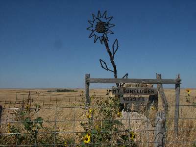

These are pictures from Mt. Sunflower, the highest point in Kansas. In actual fact, no technical skills or equipment are required to reach the summit other than about 42 miles of dirt road driving and a 10 foot walk.
Most "highpointers" - those who try to reach the highest point in each of the fifty states - are Wacky Like Me. Case in point.
To duplicate my feat, simply take the dirt road that starts at the Kanorado exit of the 70 south about 15 miles. It jogs once for about 1/8 of a mile, but stay on the southbound route after the jog. Then, you'll see a sign saying that Sunflower is 6 miles ahead. After about 5 miles, turn right and look for the U.S. flag. For more information, see this page.
This makes my fourth state highpoint, after MA, CT, and RI. My strategy is to start with the absurdly easy ones first and work up from there. I do, however, have about 15 California county highpoints, some of which are not just walk-ups.
Comments
TA (not verified)
Mon, 08/14/2006 - 07:24
Permalink
this sounds cool dude! lol... good luck! lol
Roger A.C. Williams (not verified)
Sat, 10/18/2003 - 09:59
Permalink
You mean you drove right up to it and didn't walk from the grid (cattle guard)? I did that on both visits, also walked downhill to the W. to a fence I think is the Colo. state line, then back up. Did the same thing on my 2d visit to Panorama Point, Nebr.; despite signs warning about "No walking no cycling bison on property", I walked from the tri-state point, then back again. No bison seen. I had to crawl under a fence as there was no gate.
You can also walk W. 100 yd. or so from Black Mesa, Okla. to a fence I think is the Colo. state line. Other HPs visited on borders include Rysy (2500 m.), in the High Tatra on the Polish/Czech border, and Lower Elgon (4300 m., 14 110', same as Pike's Pk.), on the Kenya/Uganda border.