

I forgot to mention I got the high point of Virginia
I climbed Mt. Rogers - Virginia's highest point - a few days ago. Oh, you want a trip report, right? Well, there isn't that much to report regarding either most of the hike or the summit of Mt. Rogers itself. As I look back on it, I don't remember any points where the trail actually went up, although there must have been some of it, because it has a gain of 1500' over 8.6 miles round-trip, some of which is on the way back. On this whole trip I've never bothered to carry my hiking poles, because I've mainly been hiking on fairly rocky trails and I usually don't use the poles in that case. While this trail has rocks on it, the poles were useful.
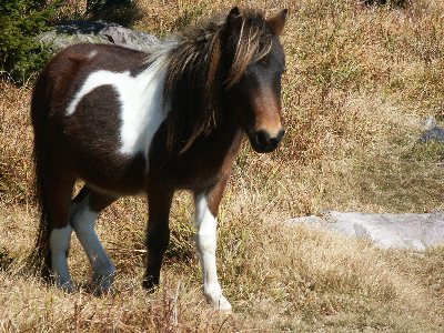
Despite the poles and the easy trail, it actually took me longer to complete the hike than the average. There are various reasons. I stopped to take pictures of the ponies, as shown above. And, I left the hiking poles behind on the top of Wilburn Ridge, and I had to double back to retrieve them. And, once I got off the Wilburn Ridge trail, I took a wrong turn for a bit. And, since I'd heard that there is a maze of trails here, I stopped to ask a few people if I was on the right trail.
Another reason is I wasn't feeling too good after a cold and somewhat annoying night at the Stone Mountain State Park campground outside Sparta, NC. The campground, surprisingly enough, was almost full, and I was unfortunate enough to be gifted with a pair of guys who arrived just before they locked the gate. It took them a few hours of slamming car doors, starting a fire, loud talking and, absolutely worst of all, playing of Kenny Loggins and Seal (no, I'm not kidding, I finally at least saw someone who buys Kenny Loggins records) before finally quieting down.
The campground host also bothered me a bit. He came around to collect the fee and asked to see my driver's license to fill out his form. I demurred, suggesting he just take the license plate number instead. "The form has a space for both your DL# and your plate. They used to just ask for a plate number, but if the car is stolen, that doesn't do any good." Great, now I'm a suspected car thief. "It's for my protection as well as yours." Strangely enough, I've heard these same lines of argumentation before, and they've been from The Fuzz! After receiving my driver's license, he "conversed" with me a bit "are you heading back to California, or heading east?" "How'd you hear about our park?" He didn't seem to be too very interested in the answers, and I felt more like I was being given a ticket by a backwoods Florida sheriff than I was renting a $12 tent site. Admittedly, I might have seemed a bit out of place, seeing as I was just one person sitting in the dark except for my headlamp eating my takeout Chinese meal. I was certainly out of place compared to the well-lit MOR party next door.
A minor bit of rural excitement happened on the way out when I stopped at the intersection of 19 and 58 outside the park. A car alarm went off, and a cow in a trailer next to it began mooing in synchronicity with the urban accessory.
As far as the "maze" of trails, despite the protestations of the rangers at the park, there is indeed a bit of a maze there: horse trails, foot trails, deer trails, etc. etc.
To avoid getting lost, follow the Rhododendron trail from Grayson Highlands State Park until you start seeing a fence ahead. (The Rhododendron Trail is a wide, road-like trail). When you see the fence, get off the wide trail, and cut across the grass to the left directly towards the fence. You should arrive at a small ladder that goes up and over, and joins the Appalachian Trail. The AT is a white-blazed trail; simply follow the white blazes almost all the way to the summit, which should be visible within a couple miles. When you get to the Thomas Knob shelter, take the right fork up to the summit, where it dead ends.
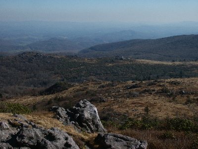
On the way back, I took the blue-blazed Wilburn Ridge trail, which has some boulder hopping and goes up and over that ridge and which provides good views: see the second pic above. It's better to take that on the way back to get the good views. Note that the WR trail meets the AT at a four-way intersection; take a right to go back to the parking lot. Don't take the first three-way intersection. Just remember, if you start seeing horse hooves, you're probably on the wrong trail.
And, just to make this painfully clear, the second pic above is from the Wilburn Ridge, and not from the summit of Mt. Rogers. The summit just has a bit of a mossy forest on it, and there's no view at all.