This page will keep track of my conditioning progress, noting trails taken, weight carried, and the time it took.
Most of this I do in Griffith Park, usually starting around noon so as to prepare myself for, for instance, a Grand Canyon hike.
I usually carry some form of weights in my pack. This consists of a combination of the following:
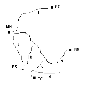
The tables below list the routes taken (see the map and legend below for an explanation), the weight carried on each leg (in pounds), the time it took, and which type of boots I was wearing. I have a pair of light trail shoes, and a heavier pair of all leather backpacking boots. Unless otherwise noted, the trails are in Griffith Park, and trekking poles were not used.
On trails b and c (see map below) I try not to use my hands. That sometimes involves downclimbing facing backwards. That slows things down, but improves my balance. I also greatly enjoy jogging down the hogback trail (part of e). Like mountain biking without the bike. Yes, I pity the poor struggling uphill hikers who suddenly notice the 200+ pound monolith hurtling straight at them at 10+ MPH.
| 9/1/2001 | Route | Weight | Time | Boots | Notes |
| Ascent | Manker Flat to Mt. Baldy via the Ski Hut Trail | 12 | 3:24 | heavy | 4.2 miles for the ascent, 3900' gain. Bad leg cramps cost me 20-30 mins. Should have drunk a sports drink before starting. |
| Descent | Mt. Baldy to Ski Lodge and the fire road | 8 | 50 mins to get from Baldy to the Lodge |
| 7/19/2001 | Route | Weight | Time | Boots | Notes |
| Ascent | up e to b, down b to d, up a to MH | 34 | 105 minutes | light | slipped twice on first part of b; should have worn heavy boots |
| Descent | down e back to RS | 6 | 33 minutes | took shortcut both ways |
| 7/17/2001 | Route | Weight | Time | Boots | Notes |
| Ascent | BS to b, up b to e, up e to MH | 39 | 41 minutes | heavy | |
| Descent | down a back to BS | 37 | ~15 minutes |
| 7/15/2001 | Route | Weight | Time | Boots | Notes |
| Ascent | Lower Sam Merrill trail: end of Lake Ave. in Pasadena to Echo Mtn. | 32 | 75 minutes | heavy | |
| Descent | return | 29 | 52 minutes | 5.5 miles RT, 1400' gain. Didn't bring enough water, not feeling too peppy either, otherwise would have gone to Inspiration Pt. |
| 7/10/2001 | Route | Weight | Time | Boots | Notes |
| Ascent | RS to MH | 50 (4 Shastas + 10lb and 5lb w.p.) | 64 minutes | light | took shortcut ("Ed's Bypass") |
| Descent | return | 21 | ~45 minutes | didn't take shortcut |
| 7/8/2001 | Route | Weight | Time | Boots | Notes |
| Ascent | TC to d, east on d, up c to e, up e to b. Down b to Vermont, up a to MH | ~30 | heavy | ||
| Descent | down e to c, down c to d, back to TC | ~6 | total trip took a little over 2.5 hours |
| recent | Route | Weight | Time | Boots | Notes |
| Ascent | BS to MH | 55 | ~35 minutes | ? | |
| Descent |
| recent | Route | Weight | Time | Boots | Notes |
| Ascent | BS to MH | 3.3 | 20 minutes | ? | no pack, just a 1.5L water bottle |
| Descent |
| May 2001, Mt. Baldy trip | Route | Weight | Time | Boots | Notes |
| Ascent | Manker Flats -> Ski Lodge -> summit | 15+ | 3.5 hours | heavy | used trekking poles |
| Descent | Ski Hut Trail | ~10 | 3 hours |
| April or May 2001, Old Mt. Wilson Trail (leads from Sierra Madre to Mt. Wilson) | Route | Weight | Time | Boots | Notes |
| Leg 1 | Sierra Madre to Orchard Camp | ~40 (15lb. pack + 25lb. w.p.) | heavy | cached the weight plate at Orchard Camp | |
| Leg 2 | Orchard Camp to Manzanita Ridge, and back down to Orchard Camp | ~15 | |||
| Leg 3 | Orchard Camp back to Sierra Madre | ~40 | carried the weight plate back down and put it back in my car | ||
| Leg 4 | Sierra Madre to Orchard Camp, and return | ~15 | total trip: ~18miles and ~5500' of gain in ~8 hours; used trekking poles |
Legend